来源: 发布时间:2022-01-03 10:12:00
编者按:
2011年11月,由北京故宫博物院、中国古陶瓷学会、福建省文物局、德化县人民政府共同主办的“2011中国瓷都・德化窑学术研讨会”在瓷都德化举办,近百位国内外博物馆馆长、从事陶瓷文化研究的专家学者齐聚瓷都德化,以“中国白的故乡、瓷艺术的摇篮”为主题,共同研讨深厚的德化窑陶瓷文化。
研讨会共提交专题论文39篇,其中不乏外国专家的作品。与会的专家学者以翔实的图文史料为佐证,从学术专业的角度对德化窑在国内外陶瓷文化领域的历史地位和影响做了全面深刻的阐述,是一笔难得的、丰硕的学术成果。
近期,《外国人眼中的“中国白”》栏目将再次回顾刊载该研讨会的相关论文,并对其中的论文进行翻译,为广大德化陶瓷文化研究爱好者提供学习、交流、参考。
Dehua Ceramics in Long-distance Trade in the Song- Yuan period:
excavations at Satingpra, South Thailand(二)
Janice Stargardt 翻译:孙延燕
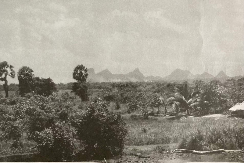
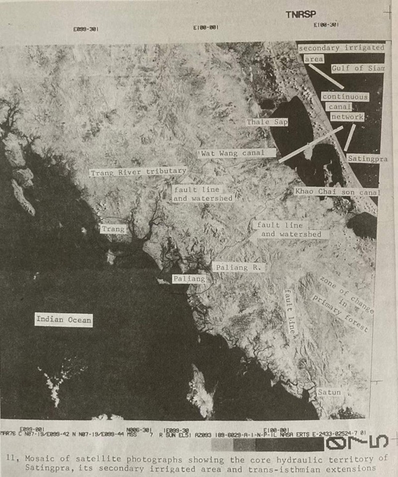
The Satingpra Peninsula, c.7.00-7.80 N and 100.50 E, is bounded on the east by the Gulf of Thailand, a part of the South China Sea, and on the west by the great chain of Songkhla Lakes which cover an area of over 100 km, north-south, and an average of 15 km in width(Figs. 1, 3). When ships crossed to the western edge of these lakes only 40 km separated them from the Indian Ocean, whereas to sail around the southern half of the Thai-Malay Peninsula was a hazardous journey of over 2000 km. As can be seen on Fig 2, the mountain ranges that run the entire length of the peninsula are, at these latitudes, a broken chain.
东临泰国湾,位于北纬7.00-7.80度、东经100.50度的塞丁普拉半岛,是南中国海的一部分。其西临宋卡大湖群,南北面积超过100公里,平均宽度为15公里(图1,3)。当船只越过这些湖泊的西部边缘时,它们与印度洋之间只有40公里的距离。而绕过泰国-马来半岛南部航行则是一次超过2000公里的危险旅程。如图2所示,贯穿整个半岛的山脉,在这些纬度上,是一条断裂的链条。

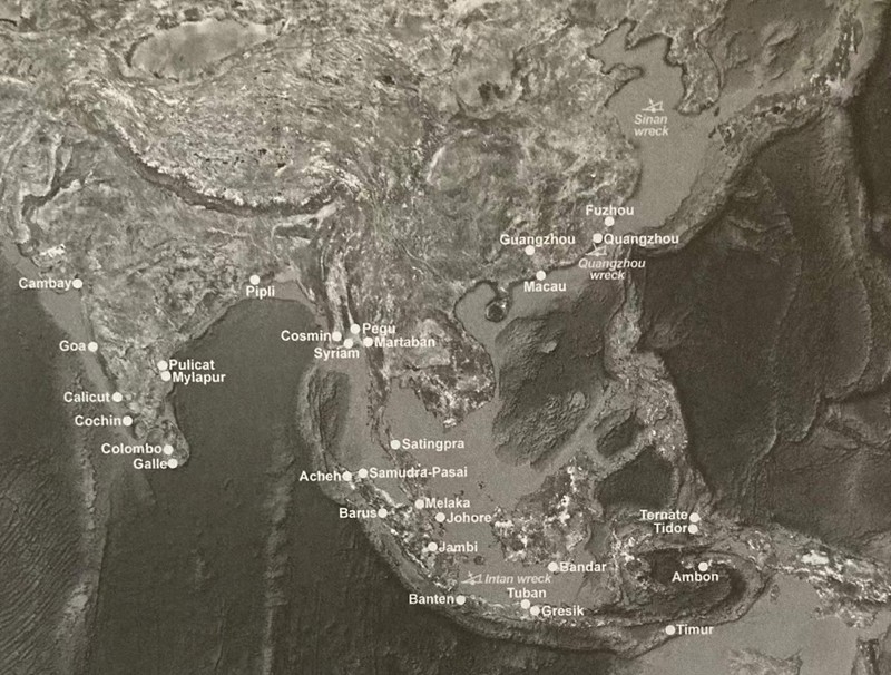
Fig.1, Regional map of Asia, with site names
图一,亚洲区域地图
Source: Google Earth

Fig.2, Gaps in the limestone ranges of Peninsular Thailand
图二,泰国半岛石灰岩山脉的山口
The breaks in the mountain ranges are caused by geological faults striking across the peninsula, which provide natural pathways. Initially such pathways were exploited by the inhabitants of the eastern plains to make contact with the mountain forest dwellers and trade with them for the precious products of the rainforest: many types and grades of incense ranging from the finest and rarest to more common varieties, as well as the commodities used in shipbuilding were harvested from this forest(Stargardt 2001 and 2005 and Table 2 below). Later, the natural pathways were used to cross from sea to sea. In c. the 6th century, a navigable canal only 4.25km long was constructed through the centre of the developing city of Satingpra, to link the Gulf of Thailand to the largest of the Songkhla Lakes(Thale Luang or Royal lake, Fig. 3). In c. the 8th century, navigable canals approx. 12 km long were constructed from the western edge of this lake to edge of the uplands. These were the Wat Wang canal and the Khao Chai Son canal(Fig 3).A short porterage route across the mountains, less than 2 km long and under 300 m in height, provided a link between these shipping canals and the two short natural rivers flowing down to Paliang and Trang on the west coast. The benefits of water transport for moving heavy, fragile loads were thus added to the pre existing trans-isthmian pathways. They were to prove very important in shifting loads of precious and fragile Chinese ceramics moving along the great trade routes of Asia in an east-west direction as well as late Roman and then Arab glass moving in the opposite direction. Fig 1 also reveals the central ity oi the location of Satingpra. At the heart of the Asian region it functioned as the portal to the Indian Ocean from the Chinese perspective and as the portal to the South China Sea from the perspective of trading partners in the Middle East, India and Java and Sumatra.
裂缝是由横跨半岛的地质断层造成的,这些断层提供了天然的通道。最初,东部平原的居民利用这个通道与山区森林居民取得联系,并与他们交易热带雨林的珍贵产品。从最好的和最稀有的到更常见的许多种类和等级的熏香,以及造船所用的物品都是从这片森林收获的。后来,天然的通道被用来跨海之间的通行。公元6世纪,一条只有4.25公里长的通航运河在发展中城市的塞丁普拉中部地区建成,将泰国湾与最大的宋卡湖(銮湖或皇家湖,图3)连接起来。公元8世纪,大约12公里长的通航运河从这个湖的西部边缘修建到高地的边缘。它们是屈望运河(Wat Wang canal,音译)和阔柴松运河(Khao Chai Son canal,音译)(图3)。一条长度不到2公里、高度不足300米,穿越山脉的短途搬运通道,提供了连接这些运河和两条天然短河之间的桥梁,这两条河流流向西海岸的马里昂和董里。水路运输沉重而易碎货物的优势增强到原有的跨地峡通道上。事实证明,它们对于沿着东西方向运送大量珍贵而脆弱的中国陶瓷器的亚洲贸易通道,以及后来朝着相反方向运输罗马和阿拉伯的玻璃都非常重要。
图一显示了塞丁普拉的中心位置。在亚洲地区的心脏地带,从中国的角度来看,塞丁普拉是通往印度洋的入口,从中东、印度、爪哇和苏门答腊的贸易伙伴的角度来看,它是通往南海的入口。

Fig. 3, Early satellite image of South Thailand, showing the transport canals of Satingpra, linking the Gulf of Thailand to the lakes and then to the Indian Ocean
图3,泰国南部的早期卫星图像,显示了塞丁普拉的运输运河,连接泰国湾和湖泊,然后到达印度洋
Source: Landsat with the authors annotations